
Maintaining the Dasgaja buffer remains a challenge. Photo credit: ANI India and Nepal are turning to drones to map a stretch of their border that, on paper, is supposed to remain empty.The area is known as Dasgaja, the no-man’s-land or buffer zone along the India-Nepal boundary. But on the ground, parts of it have been cultivated, occupied or built upon. Rivers have changed course, while thousands of boundary pillars have gone missing or been damaged.Now, the two countries want to map that mismatch from the air.At the 13th meeting of the Survey Officials’ Committee in Lucknow this month, India and Nepal agreed to use unmanned aerial vehicles to map cross-border occupation, including encroachments in Dasgaja. The joint survey is expected to begin after the monsoon, around September or October, and be completed within three years.The two sides will then jointly analyse the aerial imagery to establish how much land is being used by citizens on the other side of the recognised boundary.The move follows remarks by Nepal prime minister Balendra Shah in Parliament in May that India had encroached on Nepali land and that Nepal, too, had occupied Indian land in some places. Nepal’s foreign ministry later clarified that Shah was referring to cross-border occupation and encroachment in Dasgaja, rather than making a new territorial claim against India.What is Dasgaja?Dasgaja literally means “ten yards”. It refers to the no-man’s-land or buffer zone along the India-Nepal boundary.There is some variation in how its width is described. Indian reports generally refer to a 10-yard no-man’s-land, while a study by Nepal’s Institute of Foreign Affairs describes a 20-yard-wide buffer, with 10 yards extending from the boundary on either side.The principle is straightforward: the immediate area around the international boundary should remain free of occupation, making the border easier to identify, inspect and maintain.Why India and Nepal are turning to drones to map a border where markers, rivers and land use have complicated boundary management.In practice, that is difficult along an open border stretching about 1,880 km. The boundary runs through farmland, settlements, forests, roads and river systems, while communities on both sides maintain deep social and economic links.Nepal’s Institute of Foreign Affairs has documented people living in makeshift houses and tents within Dasgaja. Even when security forces remove such settlements, people can return.So, while Dasgaja is meant to function as a buffer on paper, parts of it have gradually become intertwined with everyday life and livelihoods along the border.An open but defined borderIndia and Nepal share an open border. There is no continuous fence separating the two countries, and people routinely cross it for work, trade, family and other activities.An open border, however, does not mean an undefined border.The international boundary is established through boundary pillars, maps and geographic coordinates. Dasgaja provides an additional buffer around that line.Maintaining the physical markers has become a persistent challenge.According to Nepal’s Department of Survey, 8,554 boundary pillars were installed along the border. Of these, 1,325 are missing and 1,956 are partially or completely damaged.A missing pillar does not automatically alter the international boundary. Its location can be reconstructed using survey records, coordinates and maps. But on the ground, the absence of a marker can make it far harder to establish where the boundary runs, particularly where fields, houses and roads are close to the line.Cross-border occupationThe drone survey goes beyond Dasgaja. India and Nepal also want to map what officials describe as cross-border occupation.These are instances in which citizens of one country live on, cultivate or otherwise use land that falls on the other side of the legally recognised boundary.Nepal’s foreign ministry said this was the issue Shah was referring to when he spoke about Nepal occupying Indian territory. It specifically linked the problem to the Fixed Boundary Principle used in riverine sections of the border.What happens when a river moves but the border doesn’t?Several sections of the India-Nepal boundary run through or alongside rivers. Rivers naturally shift course through erosion, sediment deposition and the formation of new channels.That can create complicated situations when the legal boundary is tied to a position established in earlier surveys.Under the Fixed Boundary Principle, the boundary can remain fixed even when the river around it changes course.The result can be highly unusual: a farmer may continue cultivating land that a family has used for generations, only for a later survey to establish that the land now lies on the other side of the international boundary.Missing boundary pillars and shifting river courses can make an already complex frontier harder to identify on the ground.Nepal’s foreign ministry identified such riverine changes as one reason for cross-border occupation. Nepal’s Kantipur has reported that decades of river-course changes have shifted thousands of hectares of land from one side of the border to the other.Most of the border is mappedThe new drone survey is not an attempt to redraw or rediscover the India-Nepal boundary.Technical boundary work dates back to 1981, when the Joint Technical Level Nepal-India Boundary Committee was established.After years of surveying, the committee prepared 182 strip maps covering about 98 per cent of the boundary. The maps were finalised in 2007 and excluded the unresolved areas of Kalapani and Susta.India’s ministry of external affairs has also recorded that the strip maps covering 98 per cent of the boundary were authenticated in 2007.But the maps were never formally ratified by both countries as a final settlement.Nepal maintained that outstanding disputes had to be resolved, while India sought their endorsement.Even so, they remain an important technical reference.Why are boundary pillars a problem?A boundary line on a map can be difficult to identify in a field without a physical marker.That is why India and Nepal maintain thousands of boundary pillars along the frontier. But many have been damaged, destroyed or lost, particularly in areas affected by rivers and erosion.The two countries have been working to restore them. At the seventh meeting of the Boundary Working Group in July 2025, India and Nepal agreed to jointly construct new pillars and repair damaged ones as part of their technical boundary work.Established in 2014, the Boundary Working Group deals with issues including the clearing of no-man’s-land, construction and maintenance of boundary pillars, updating cross-border property records and other technical border matters.It does not cover the unresolved Kalapani and Susta disputes.The technical mechanism operates at three levels: the Boundary Working Group, the Survey Officials’ Committee and Joint Field Survey Teams. Field teams conduct ground surveys, while the SOC and BWG examine the findings and determine the next technical steps.India and Nepal are using drone technology to survey parts of their open border where physical markers and changing landscapes create uncertainty.Why use drones now?The immediate objective is simple: get a far more precise picture of what is happening on the ground.The UAVs will capture aerial images of areas where cross-border occupation is suspected. Indian and Nepali officials will then analyse the imagery jointly and compare it with existing maps, coordinates, boundary pillars and field records.Aerial imagery can show precisely where fields, houses, roads, rivers and other physical features sit in relation to the established boundary.But the most important element is not the drone. It is the joint verification.If both countries work from the same imagery and agree on the technical facts of a particular location, it becomes easier to determine what needs to happen next.The jointly verified record could eventually provide a basis for negotiating the removal of encroachments, restoration of land or, where necessary, compensation.Is this related to Kalapani and Lipulekh?The India-Nepal border has several separate disputes.Kalapani, Lipulekh and Limpiyadhura concern Nepal’s territorial claims in the western sector and competing interpretations of historical maps, documents and the course of the Kali or Mahakali River.Susta is another separate dispute involving changes in the course of the Gandak or Narayani River.The current technical mechanism does not cover these unresolved areas. The 2025 BWG agreement specifically kept Susta and Kalapani-Lipulekh-Limpiyadhura outside its technical work.The Dasgaja exercise is narrower. It deals with no-man’s-land, boundary infrastructure and cross-border occupation along the established boundary.What this drone survey really meansAt first glance, sending drones over Dasgaja may look like a relatively routine surveying exercise. It is anything but.The India-Nepal border is unusual: open to people, but fixed in law; socially intertwined, but internationally sovereign. Over decades, rivers have shifted, settlements have expanded, farms have crossed invisible lines and boundary markers have disappeared.Join conversationView All Comments →Share your thoughts in the commentsInsightfulAgreeDisagreeSkepticalConcerningPromisingWorth ReadingBig DevelopmentPost CommentBe respectful · TOI community guidelinesThat has created a gap between the border that exists on maps and the border experienced on the ground.The drones are an attempt to close that gap with evidence.They will not settle Kalapani. They will not redraw the map. And they will not, by themselves, resolve every dispute over land.But they could give India and Nepal something that has often been missing in sensitive border discussions: a shared, current and verifiable picture of what is actually happening on the ground.Get the latest India News and Live updates. Download the TOI app.About the AuthorSubhadra SrivastavaSubhadra Srivastava is a journalist with The Times of India, covering geopolitics, international and national affairs. With over three years of experience, she focuses on national and global developments, conflict, diplomacy and their impact on India. Her work combines breaking news with in-depth analysis, offering readers context and clarity on the stories shaping the world.Read MoreEnd of ArticleFollow Us On Social MediaVideos105 Indians Missing In Nepal Flash Floods; Tibet-Side Surge Leaves Eight Dead | Watch‘Big Reveal’ Or Big Scam? August 25 Insta Account Make Hype Sparks ₹8.5 Crore Scam Row’Hijab On Heads, Not Minds’: Owaisi Calls Allahabad High Court Ruling ‘Attack On Islam’‘Do We Need A 4th-Party Audit?’: PM Modi Raps Secretaries, Flags Quality Issues In Public ProjectsAhmedabad-Mumbai Bullet Train Cost Revised To Rs 2 Lakh Crore, Nearly 2x Of Original EstimateGovt Seeks 2 Years To Frame OBC Creamy Layer Criteria For PSU, Private Staff KidsPakistan Tried Chinese Satellites For Op Sindoor Evidence But Failed, Says Ex-CDS Anil ChauhanPak’s Nuke Storage Area Kirana Hills Hit In Op Sindoor? Ex-cds Anil Chauhan Reveals Shocking DetailsBihar BPSC Protest Explodes In Patna As Students Break Barricades, Police Use Water Cannons | WatchIndia Opens DRDO Missile Technologies To Defence Firms In Major Push For Indigenous Production123PhotostoriesRaksha Bandhan 2026: 10 beautiful mehendi designs to elevate your Rakhi lookTired of lemons going dry or mouldy? Here’s how to store them the right wayFrom washing dishes for Rs 1,800 to being asked to return to work after a miscarriage and later being fired after pregnancy: When Smriti Irani opened up about her struggles5 jewellery gifts your sister will love showing off this Raksha BandhanWhat is skin cycling: Trend or science?What happens when you place tissue paper in an electric sandwich maker: 3 smart ways to clean itRaksha Bandhan 2026: Gift ideas for your sibling based on their birth numberPut aluminium foil in your freezer: The surprisingly useful kitchen hack people swear byFrom denying ex-GF Himanshi Khurana’s conversion allegations and calling her a ‘Fame Digger’ to referring to Paras Chhabra as a ‘fat Pig’: Asim Riaz hits backThese idols are often said to be unsuitable for a home temple, here’s what Hindu traditions and Vastu actually say123Hot PicksSchool holidays todayBank holiday todayBSE holiday todayKerala name changeICSI CS june resultNEET UG 2026Sridhar VembuVenkata Narasamamba VasamsettyNEET PG 2026 admit cardTop TrendingAndhra Pradesh Woman Deportation CaseSuresh GowdaHyderabad AccidentIIT Delhi Student DeathBihar Dolphin NewsMumbai Airport DemolitionRam RahimDelhi Women AccidentKangana RanautMaharashtra Hill Tragedy

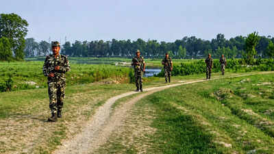
India and Nepal are turning to drones to map a stretch of their border that, on paper, is supposed to remain empty.The area is known as Dasgaja, the no-man’s-land or buffer zone along the India-Nepal boundary. But on the ground, parts of it have been cultivated, occupied or built upon. Rivers have changed course, while thousands of boundary pillars have gone missing or been damaged.Now, the two countries want to map that mismatch from the air.At the 13th meeting of the Survey Officials’ Committee in Lucknow this month, India and Nepal agreed to use unmanned aerial vehicles to map cross-border occupation, including encroachments in Dasgaja. The joint survey is expected to begin after the monsoon, around September or October, and be completed within three years.The two sides will then jointly analyse the aerial imagery to establish how much land is being used by citizens on the other side of the recognised boundary.The move follows remarks by Nepal prime minister Balendra Shah in Parliament in May that India had encroached on Nepali land and that Nepal, too, had occupied Indian land in some places. Nepal’s foreign ministry later clarified that Shah was referring to cross-border occupation and encroachment in Dasgaja, rather than making a new territorial claim against India.
What is Dasgaja?
Dasgaja literally means “ten yards”. It refers to the no-man’s-land or buffer zone along the India-Nepal boundary.There is some variation in how its width is described. Indian reports generally refer to a 10-yard no-man’s-land, while a study by Nepal’s Institute of Foreign Affairs describes a 20-yard-wide buffer, with 10 yards extending from the boundary on either side.The principle is straightforward: the immediate area around the international boundary should remain free of occupation, making the border easier to identify, inspect and maintain.
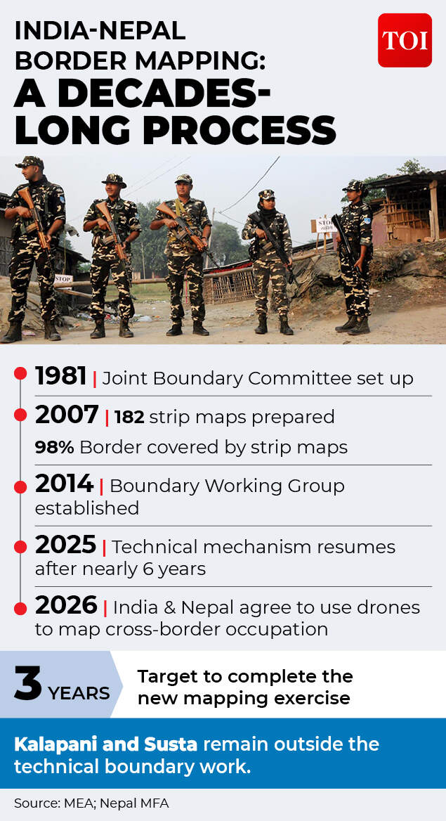
Why India and Nepal are turning to drones to map a border where markers, rivers and land use have complicated boundary management.
In practice, that is difficult along an open border stretching about 1,880 km. The boundary runs through farmland, settlements, forests, roads and river systems, while communities on both sides maintain deep social and economic links.Nepal’s Institute of Foreign Affairs has documented people living in makeshift houses and tents within Dasgaja. Even when security forces remove such settlements, people can return.So, while Dasgaja is meant to function as a buffer on paper, parts of it have gradually become intertwined with everyday life and livelihoods along the border.
An open but defined border
India and Nepal share an open border. There is no continuous fence separating the two countries, and people routinely cross it for work, trade, family and other activities.An open border, however, does not mean an undefined border.The international boundary is established through boundary pillars, maps and geographic coordinates. Dasgaja provides an additional buffer around that line.Maintaining the physical markers has become a persistent challenge.According to Nepal’s Department of Survey, 8,554 boundary pillars were installed along the border. Of these, 1,325 are missing and 1,956 are partially or completely damaged.A missing pillar does not automatically alter the international boundary. Its location can be reconstructed using survey records, coordinates and maps. But on the ground, the absence of a marker can make it far harder to establish where the boundary runs, particularly where fields, houses and roads are close to the line.
Cross-border occupation
The drone survey goes beyond Dasgaja. India and Nepal also want to map what officials describe as cross-border occupation.These are instances in which citizens of one country live on, cultivate or otherwise use land that falls on the other side of the legally recognised boundary.Nepal’s foreign ministry said this was the issue Shah was referring to when he spoke about Nepal occupying Indian territory. It specifically linked the problem to the Fixed Boundary Principle used in riverine sections of the border.
What happens when a river moves but the border doesn’t?
Several sections of the India-Nepal boundary run through or alongside rivers. Rivers naturally shift course through erosion, sediment deposition and the formation of new channels.That can create complicated situations when the legal boundary is tied to a position established in earlier surveys.Under the Fixed Boundary Principle, the boundary can remain fixed even when the river around it changes course.The result can be highly unusual: a farmer may continue cultivating land that a family has used for generations, only for a later survey to establish that the land now lies on the other side of the international boundary.
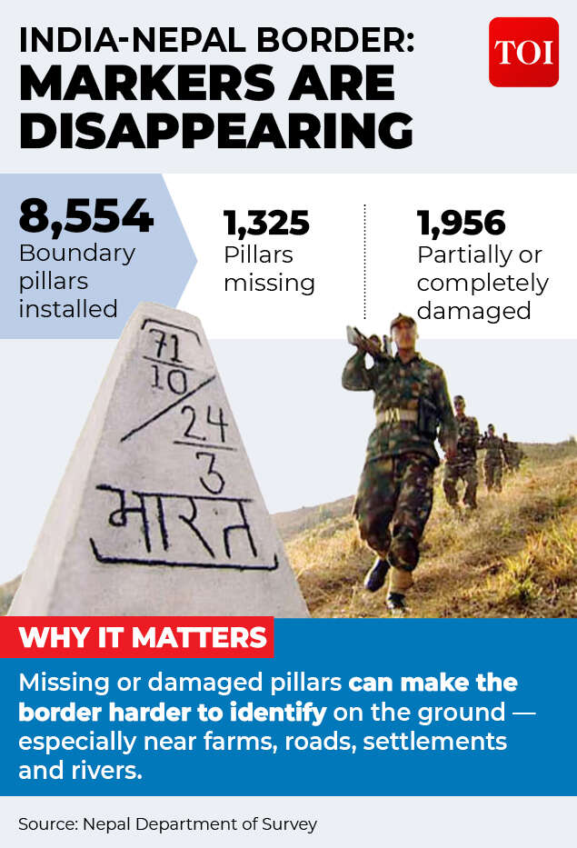
Missing boundary pillars and shifting river courses can make an already complex frontier harder to identify on the ground.
Nepal’s foreign ministry identified such riverine changes as one reason for cross-border occupation. Nepal’s Kantipur has reported that decades of river-course changes have shifted thousands of hectares of land from one side of the border to the other.
Most of the border is mapped
The new drone survey is not an attempt to redraw or rediscover the India-Nepal boundary.Technical boundary work dates back to 1981, when the Joint Technical Level Nepal-India Boundary Committee was established.After years of surveying, the committee prepared 182 strip maps covering about 98 per cent of the boundary. The maps were finalised in 2007 and excluded the unresolved areas of Kalapani and Susta.India’s ministry of external affairs has also recorded that the strip maps covering 98 per cent of the boundary were authenticated in 2007.But the maps were never formally ratified by both countries as a final settlement.Nepal maintained that outstanding disputes had to be resolved, while India sought their endorsement.Even so, they remain an important technical reference.
Why are boundary pillars a problem?
A boundary line on a map can be difficult to identify in a field without a physical marker.That is why India and Nepal maintain thousands of boundary pillars along the frontier. But many have been damaged, destroyed or lost, particularly in areas affected by rivers and erosion.The two countries have been working to restore them. At the seventh meeting of the Boundary Working Group in July 2025, India and Nepal agreed to jointly construct new pillars and repair damaged ones as part of their technical boundary work.Established in 2014, the Boundary Working Group deals with issues including the clearing of no-man’s-land, construction and maintenance of boundary pillars, updating cross-border property records and other technical border matters.It does not cover the unresolved Kalapani and Susta disputes.The technical mechanism operates at three levels: the Boundary Working Group, the Survey Officials’ Committee and Joint Field Survey Teams. Field teams conduct ground surveys, while the SOC and BWG examine the findings and determine the next technical steps.
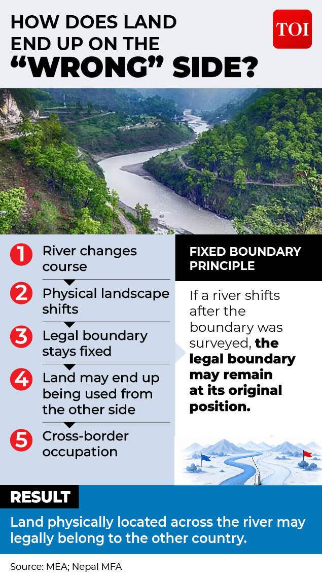
India and Nepal are using drone technology to survey parts of their open border where physical markers and changing landscapes create uncertainty.
Why use drones now?
The immediate objective is simple: get a far more precise picture of what is happening on the ground.The UAVs will capture aerial images of areas where cross-border occupation is suspected. Indian and Nepali officials will then analyse the imagery jointly and compare it with existing maps, coordinates, boundary pillars and field records.Aerial imagery can show precisely where fields, houses, roads, rivers and other physical features sit in relation to the established boundary.But the most important element is not the drone. It is the joint verification.If both countries work from the same imagery and agree on the technical facts of a particular location, it becomes easier to determine what needs to happen next.The jointly verified record could eventually provide a basis for negotiating the removal of encroachments, restoration of land or, where necessary, compensation.
Is this related to Kalapani and Lipulekh?
The India-Nepal border has several separate disputes.Kalapani, Lipulekh and Limpiyadhura concern Nepal’s territorial claims in the western sector and competing interpretations of historical maps, documents and the course of the Kali or Mahakali River.Susta is another separate dispute involving changes in the course of the Gandak or Narayani River.The current technical mechanism does not cover these unresolved areas. The 2025 BWG agreement specifically kept Susta and Kalapani-Lipulekh-Limpiyadhura outside its technical work.The Dasgaja exercise is narrower. It deals with no-man’s-land, boundary infrastructure and cross-border occupation along the established boundary.
What this drone survey really means
At first glance, sending drones over Dasgaja may look like a relatively routine surveying exercise. It is anything but.The India-Nepal border is unusual: open to people, but fixed in law; socially intertwined, but internationally sovereign. Over decades, rivers have shifted, settlements have expanded, farms have crossed invisible lines and boundary markers have disappeared.
Share your thoughts in the comments
Be respectful · TOI community guidelines
That has created a gap between the border that exists on maps and the border experienced on the ground.The drones are an attempt to close that gap with evidence.They will not settle Kalapani. They will not redraw the map. And they will not, by themselves, resolve every dispute over land.But they could give India and Nepal something that has often been missing in sensitive border discussions: a shared, current and verifiable picture of what is actually happening on the ground.


