
The deadly forces behind Nepal’s Himalayan disasters

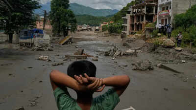
On the morning of August 26, high in Langtang National Park near Nepal’s border with China, a massive wall of ice and rock suddenly broke loose.Within minutes, it had transformed into a violent debris flow and flood surge, racing almost 100 km down the Lende Khola, Bhote Koshi and Trishuli rivers. It tore through villages on both sides of the frontier, obliterated the Rasuwagadhi border complex and left a trail of destruction in its wake.There was no earthquake.The US Geological Survey initially recorded a magnitude 4.4 tremor, only to retract it. The apparent “earthquake” had not shaken the mountain — the collapsing mass itself had generated the seismic signal. The event was later upgraded to magnitude 5.2.There was no rainfall trigger either; and, crucially, there was almost no warning.Speed defined the disaster. Readings relayed by the World Meteorological Organisation show that the Trishuli River at Galchhi rose by as much as nine metres in just 30 minutes; at Malekhu, it rose seven metres over a similar period.By the morning of August 29, Nepal’s disaster authority, NDRRMA, had put the toll at 626 dead and 2,426 missing, with more than 3,700 rescued.China separately reported seven dead and 554 missing across the border in Tibet.The destruction stretched far beyond the immediate flood zone. Twelve hydropower plants were reportedly knocked offline, dozens of bridges were swept away and the only road connecting the valley to the rest of Nepal was destroyed.But the Rasuwa disaster was not an isolated event. It was the latest and deadliest expression of a question Nepal has repeatedly had to confront:Why does a country so accustomed to natural disasters remain so vulnerable when they strike?
Not the first
The Rasuwa flood sits inside a documented, decades-long pattern.Nepal’s disaster authority recorded more than 32,000 separate incidents between 2018 and 2024 alone, killing almost 3,700 people across a wide range of hazards, including earthquakes, floods, landslides, avalanches and glacial outbursts.The defining event remains the 2015 Gorkha earthquake. The magnitude 7.8 quake killed 8,896 people and caused roughly $7 billion in damage, equivalent to nearly a third of Nepal’s economy at the time. It also triggered a rockfall-avalanche and air blast that levelled the village of Langtang, killing more than 350 people.
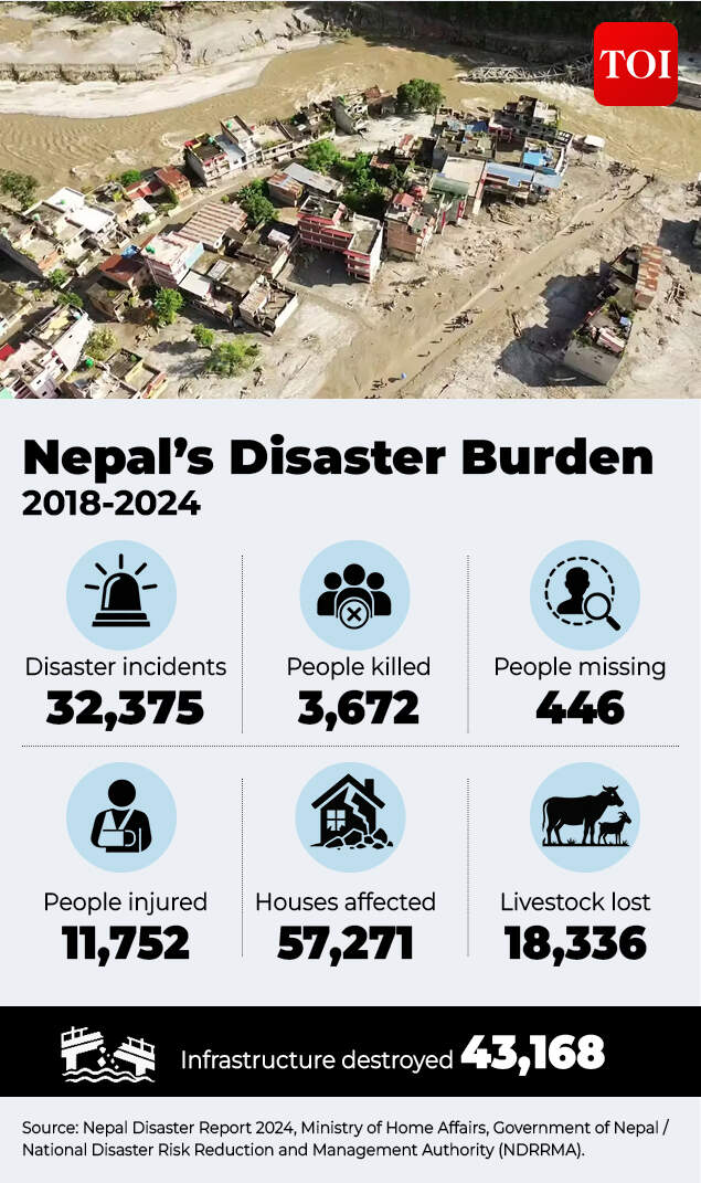
Disaster damage faced by Nepal between 2018-2024.
Other disasters illustrate the range of threats.The 2014 Jure landslide dammed the Sunkoshi River and killed 156 people. The 1985 Dig Tsho glacial lake outburst flood destroyed a nearly completed hydropower plant. In 2021, rainfall and two landslides sent roughly 13 million cubic metres of debris downstream in the Melamchi disaster. The 2023 Jajarkot earthquake killed 154 people. And, tellingly, the same Rasuwa valley was hit by a flood in July 2025 after the sudden drainage of a glacial lake that had formed only months earlier.Against this backdrop, Germanwatch’s Climate Risk Index 2026 ranked Nepal the sixth most affected country in the world for 2024. But that finding has often been misrepresented. The index is retrospective: it measures recorded deaths, people affected and economic losses from extreme weather in a particular year, rather than vulnerability or future risk.Nepal’s 2024 ranking was driven mainly by monsoon floods and landslides across 44 districts in September, which killed 249 people and caused an estimated 46.7 billion rupees in damage. It is evidence of the scale of Nepal’s exposure to extreme weather, but it does not, by itself, explain why disasters keep occurring.
The ‘underlying’ problem
The explanation begins with plate tectonics.Nepal sits directly above the boundary where the Indian plate is being driven beneath Eurasia. The collision is located along the Main Himalayan Thrust, a major fault that continues to accumulate strain and periodically releases it through large earthquakes.
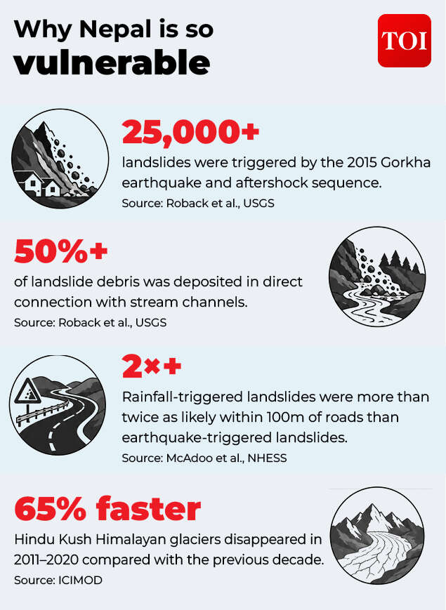
How Nepal’s geology makes it vulnerable to natural disasters.
The Himalayas are geologically young because this collision, which began roughly 50 million years ago, is still pushing the range upwards. Unlike older, heavily eroded mountain belts, the Himalayas have had relatively little time to soften. The result is some of the steepest terrain on Earth compressed into a relatively short horizontal distance.That combination of steep slopes and active tectonics has serious consequences. A peer-reviewed analysis of the 2015 Gorkha earthquake found that it triggered at least 25,000 landslides, closely mirroring the extent of the fault rupture. The worst damage occurred where three factors overlapped: steep slopes, heavy rainfall and proximity to the deepest rupture.Crucially, more than half of the landslide debris came to rest in stream channels, leaving rivers seeded with loose material that can continue to contribute to blockages and floods years later. The steep terrain also amplifies ground shaking, meaning an earthquake of the same magnitude can cause greater damage on a high, steep slope than on flatter terrain.This helps explain why a single event in the Himalayas can rapidly become a chain of hazards. At Langtang, anomalous heavy snowfall during the preceding winter combined with minor earthquakes throughout the year may have eventually led to the rockfall-avalanche.A study of the 2021 Melamchi disaster similarly found that multiple climatic and human factors acted together at different points along the river rather than a single trigger causing the disaster.The cliché that “nature” alone is responsible therefore misses the point. The young Himalayas provide the steep terrain and seismic energy; rainfall, ice, unstable slopes and rivers determine how that energy is converted into landslides, river blockages and floods.
Climate change and human activity are amplifying risks
Geology provides the foundation, but a warming high-mountain environment is adding another layer of risk.Regional assessments describe changes in the Hindu Kush Himalaya cryosphere as “unprecedented and largely irreversible”. Glaciers retreated 65 per cent faster in the 2010s than in the preceding decade, while high elevations have warmed considerably faster than the global average.Warming, combined with permafrost thaw, can destabilise high-altitude rock slopes. Scientists say this can contribute to the kind of rock-ice avalanche suspected at Rasuwa. As Jakob Steiner of the University of Graz put it, “The chances that material starts to move down from mountains increase.”Scientists have nevertheless cautioned against drawing a direct line between climate change and the Rasuwa event before its precise cause is established.The picture is less straightforward when it comes to glacial lake outburst floods.The strongest available study on such floods in the Himalayas found no clear increase in their frequency in recent decades, even though scientists project that the underlying risk could roughly triple with continued glacier retreat. In other words, observed frequency and projected future risk are not necessarily moving in tandem.Rainfall trends are similarly complicated.National rainfall records from 1971 to 2015 show that extreme precipitation has, on average, weakened, even as year-to-year variability has increased.Human development, however, has clearly increased exposure.A 2018 study found that rainfall-triggered landslides were more than twice as likely within 100 metres of a road than at randomly selected locations, largely because informal road construction can oversteepen slopes and disrupt drainage.Kathmandu Valley has expanded by 4 to 6 per cent a year amid what the World Bank has described as “haphazard and unplanned urbanisation”.Governments have also repeatedly rebuilt hydropower plants, roads and border infrastructure in the same hazard-prone valleys where disasters have struck before.One popular explanation, however, does not stand up well to the evidence: deforestation. Nepal’s forest cover nearly doubled between 1992 and 2016.Nepal cannot change its geology, climate change and development, however, can alter the conditions in which hazards occur; and, crucially, determine how many people and how much infrastructure are in their path.
Why hazards become disasters
Nepal has significantly strengthened its disaster-management architecture since 2015. It passed the Disaster Risk Reduction and Management Act in 2017 and created the National Disaster Risk Reduction and Management Authority, or NDRRMA, in 2019.Yet there remains a gap between having institutions on paper and having systems capable of anticipating fast-moving mountain hazards. The World Bank’s 2024 assessment found Nepal’s legislative framework to be advanced, while describing its institutional arrangements for coordinating preparedness as still relatively basic.Nepal’s flood-warning systems can work effectively when monitoring the hazards they were designed to detect. Its best-performing system, on the Karnali River, can provide downstream communities with two to three hours of warning once water crosses a threshold gauge.Rasuwa presented a fundamentally different challenge.The surge crossed into Nepal at roughly 8.40am. The Flood Forecasting Division received word at 8.56am and issued a warning within four minutes. But by then, the flood had already reached much of the district. The gauging stations that were supposed to track the surge were themselves destroyed before they could transmit further information.As Shushil Kumar Shrestha, a senior NDRRMA engineer, told the New York Times: “The flood developed so rapidly that people simply did not have enough time to get to safety, even though the system was functioning.”The same preparedness gap is visible in construction. Nepal’s updated seismic code, introduced after the 2015 earthquake, still had an 89 per cent non-compliance rate recorded in 2016.The underlying gap, as experts have put it, is that Nepal is far better at tracking floods once they enter monitored rivers than at detecting the high-mountain hazards, glacier collapses, ice avalanches, landslide-dammed lakes that create them.Nepal cannot stop the Indian plate from colliding with Eurasia. It cannot prevent every unstable slope from failing thousands of metres above a remote valley.But it can narrow the gap between hazard and disaster.That means better monitoring of high-altitude slopes and glaciers, stronger early-warning networks, more resilient infrastructure, stricter construction standards, better land-use planning and evacuation systems designed for events that can unfold in minutes rather than hours.


