
Seattle’s ‘Emerald City’ from space: How glaciers and people shaped its landscape

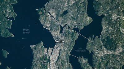
Seen from space, Seattle stands out as a vibrant patchwork of deep green forests, blue waterways and dense urban development. The city’s famous nickname, the “Emerald City”, reflects the evergreen trees that surround it, but its landscape tells a much older story than modern skylines and parks. Long before Seattle became a major Pacific Northwest metropolis, immense glaciers carved its hills, valleys and lakes during the last Ice Age. More recently, people have dramatically reshaped the terrain, flattening hills, filling tidal flats and altering waterways to support a growing city. A new image released by Nasa Earth Observatory highlights how both natural forces and human engineering combined to create the distinctive landscape visible from orbit today.
Nasa’s satellite view reveals Seattle’s striking geography
The image offers a striking bird’s-eye view of Seattle and the surrounding Puget Sound region. From orbit, the city appears as a dense urban corridor framed by expansive forests, winding waterways and rugged terrain, illustrating why it is regarded as one of the greenest major cities in the United States.Seattle occupies a narrow isthmus between Puget Sound to the west and Lake Washington to the east, with Lake Union nestled near the city’s centre. The city’s waterfronts, bays and inlets blend seamlessly with densely forested hills, while the evergreen canopy stretching beyond the metropolitan area has earned Seattle its long-standing nickname, the “Emerald City.”The satellite image also highlights how closely Seattle’s development is tied to water. Rivers, lakes, canals and coastlines divide neighbourhoods, shape transport corridors and connect the city to regional and international shipping routes through Puget Sound. Bridges span major waterways, while ports, marinas and ferry terminals are clearly integrated into the urban landscape, demonstrating how geography has influenced Seattle’s growth from a small settlement into one of the Pacific Northwest’s most important economic and cultural centres.
Ancient glaciers sculpted Seattle long before the city existed
According to Nasa, much of Seattle’s present-day landscape was shaped thousands of years ago by the Cordilleran Ice Sheet, a vast mass of ice that blanketed much of the Pacific Northwest during the last Ice Age. At its greatest extent, the ice sheet was hundreds of metres thick, dramatically altering the region’s terrain as it slowly advanced and retreated over thousands of years.The immense weight and movement of the glaciers carved broad U-shaped valleys, scoured the bedrock and deposited thick layers of sand, gravel and clay. These glacial processes created the rolling hills and ridges that define Seattle today, while also helping to form Puget Sound by deepening ancient river valleys that were later flooded by seawater. The glaciers also excavated large basins that eventually filled with freshwater, giving rise to lakes such as Lake Washington and Lake Union.Nasa notes that this Ice Age legacy continues to influence the city’s layout. The hills, waterways and natural landforms created by the glaciers determined where roads, bridges, neighbourhoods and ports could be built, meaning Seattle’s modern urban landscape still follows patterns established thousands of years before the city’s founding.
Humans dramatically reshaped the Emerald City
Although glaciers laid the foundations, much of Seattle’s present-day landscape reflects more than a century of human engineering.Beginning in the late nineteenth century, city planners undertook a series of ambitious projects known as the Seattle regrades, during which several steep hills were partially levelled using powerful hydraulic water jets. The excavated soil was transported to fill nearby tidal flats and low-lying areas, creating more space for urban expansion.Engineers also altered local waterways. The construction of the Lake Washington Ship Canal connected Lake Washington, Lake Union and Puget Sound, lowering the level of Lake Washington by several feet and transforming shorelines throughout the city.These large-scale modifications permanently changed Seattle’s natural geography while supporting its growth into one of the Pacific Northwest’s largest urban centres.
A landscape shaped by both nature and engineering
From space, Seattle appears as a harmonious mosaic of evergreen forests, sparkling waterways and dense urban neighbourhoods, but beneath that striking landscape lies a history shaped over thousands of years. Every ridge, shoreline and lake visible from orbit reflects a combination of powerful natural forces and ambitious human engineering.The glaciers of the last Ice Age carved the hills, valleys and basins that became Puget Sound, Lake Washington and Lake Union, establishing the region’s distinctive geography. Centuries later, people transformed that glacial landscape by levelling hills, filling tidal flats, constructing canals and expanding waterfronts to support a rapidly growing city, major ports and modern transport networks.Nasa’s latest Earth Observatory image offers far more than a spectacular satellite view. It captures the remarkable story of how geological processes spanning millennia and more than a century of human development combined to create the landscape that earned Seattle its enduring title as the “Emerald City.”


