
The ‘fire-breathing dragon of clouds’ over France: When a wildfire creates its own weather

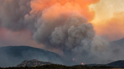
Imagine a wildfire so powerful that it begins creating its own weather.That is what happened in France, where a monster wildfire burning across an area four times the size of Paris produced the country’s first recorded ‘fire cloud’. A towering storm formed by heat and smoke rising from the flames. It can generate powerful winds, lightning and even spark fresh fires.Nasa has called it the “fire-breathing dragon of clouds”, and the name fits. Most wildfires are shaped by the weather around them. This one becomes powerful enough to influence the atmosphere above it.
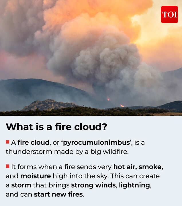
A fire cloud, or ‘pyrocumulonimbus’, is a thunderstorm made by a big wildfire.
The phenomenon emerged as Europe battles an intense wildfire season.Successive heatwaves and prolonged drought have dried out vegetation across France, Spain, Greece and Turkey, creating ideal conditions for fires to spread rapidly. Large areas have burned, thousands have been evacuated and firefighters have struggled to contain blazes made more unpredictable by heat and wind.But a fire cloud adds another layer of danger. It can pull in strong winds, carry burning embers over long distances and produce lightning capable of igniting new fires.So how does a wildfire build a thunderstorm? Why are these clouds so dangerous? And as Europe grows hotter and drier, could they become more common?
Before the fire built a storm, Europe had become a tinderbox
The fire cloud over France did not appear out of nowhere. Weeks of extreme heat and drought had prepared the ground for it.Earlier wet weather had helped plants grow rapidly. But as temperatures climbed and rainfall disappeared, that vegetation dried out, leaving behind plenty of fuel for fires.France and Spain have been among the worst-hit countries in Europe. In southwestern France, the Gironde fires have burned through 42,000 hectares, an area around four times the size of Paris. At the peak of the crisis, hundreds of thousands of residents and tourists were forced to leave homes, campsites and holiday destinations across France and Spain.
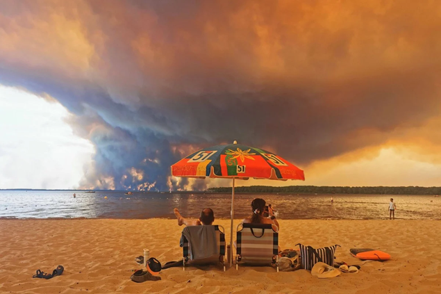
Towering smoke clouds rise above a wildfire as beachgoers look on in Southern France. Picture credit: AFP
The emergency has stretched from the Atlantic coast to the eastern Mediterranean. Firefighters have also battled blazes in Greece and Turkey, where flames have threatened villages and tourist areas.There are now some signs of relief in France. Cooler temperatures, higher humidity and the possibility of rain have slowed the fire’s expansion. But more than 2,000 firefighters and over 20 aircraft remain deployed, and officials have warned that conditions could worsen again.Even if the flames are beginning to ease, this season has already shown how quickly heat, drought and dry vegetation can turn an ordinary fire into something far more powerful.
When smoke becomes a storm
Every wildfire sends smoke into the sky. But only the most intense ones produce enough heat to turn that smoke into something far more powerful.As a wildfire burns, it releases an enormous amount of heat. That heat lifts a column of hot air, smoke, ash and moisture high into the atmosphere, much like a chimney. The plume continues to rise and cools as it climbs. Eventually, the moisture condenses around tiny particles of smoke and ash, forming a cloud directly above the fire.
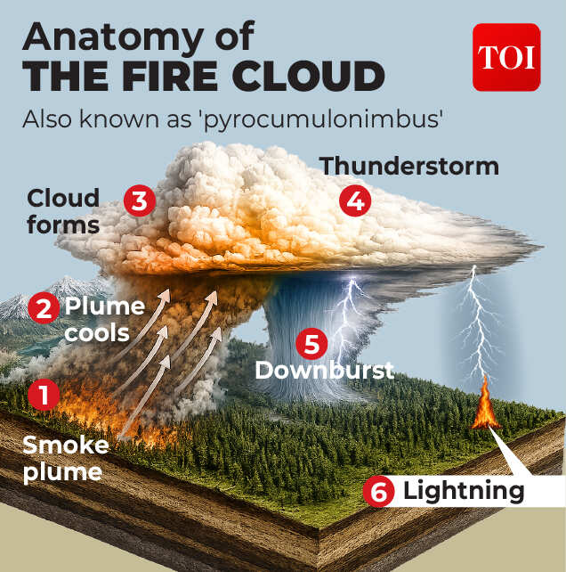
How a wildfire becomes a fire cloud
According to Dr Kirti Avishek, associate professor in the department of remote sensing and Geoinformatics at Birla Institute of Technology, Mesra, three conditions must come together for this transformation to occur.First, there must be “an unusually intense, fast-moving fire” releasing enough heat to drive the plume upwards. Second, “the atmosphere above the fire has to be unstable enough to let that plume keep rising rather than flattening out”. And third, there must be “sufficient moisture, from the burning vegetation itself and from the surrounding air”, for water vapour to condense as the plume cools.At first, this is known as a ‘pyrocumulus’ cloud. On its own, it is not unusual during large wildfires. But sometimes the fire is so intense that the cloud refuses to stop growing.As more moisture condenses, it releases heat that pushes the cloud even higher. If atmospheric conditions are favourable, the cloud continues to build until it becomes a towering thunderstorm, known as a ‘pyrocumulonimbus’ or simply, a fire cloud.“That is what turns a smoke column into an actual cloud, and in extreme cases a thunderstorm-like structure capable of producing lightning,” Avishek said.What makes it remarkable is not just how it forms, but what powers it. Unlike ordinary thunderstorms, which develop because the sun heats the Earth’s surface, a fire cloud draws its energy almost entirely from the wildfire burning below.In other words, the blaze has become powerful enough to create a storm of its own.
Why firefighters fear a fire cloud
A fire cloud is not dangerous only because how dramatic it looks. It is dangerous because it can make an already unpredictable wildfire even harder to control.The towering cloud acts almost like a giant chimney, pulling air towards the fire from every direction. Those strong inflowing winds feed the flames with fresh oxygen, helping the fire burn hotter and spread faster. A blaze that appeared to be moving in one direction can suddenly change course, leaving firefighters with little time to react.
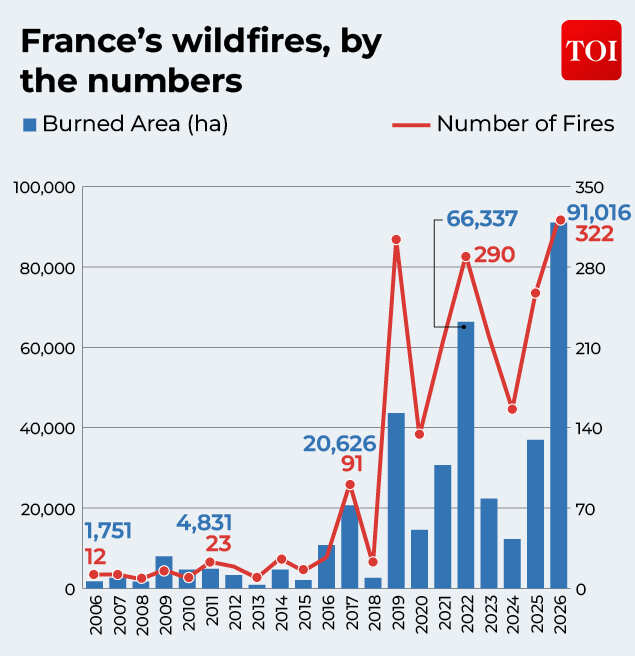
How 2026 became France’s most destructive wildfire year in two decades
The powerful updrafts inside a fire cloud can lift burning twigs, bark and other debris thousands of metres into the air. Carried by the wind, those embers can land kilometres away, igniting fresh fires well beyond the original fire line. During Australia’s Black Saturday bushfires in 2009, one such “spot fire” was recorded more than 30 kilometres from the parent blaze.The cloud can also generate lightning. Unlike an ordinary thunderstorm that moves over a landscape, this storm is born from the fire itself.A lightning strike can ignite another patch of dry vegetation, creating new fires even as firefighters are still battling the first.And then there is the wind from above.Rain may form inside the cloud, but much of it evaporates before reaching the ground because the air below is so hot and dry. That cooling air plunges rapidly towards the surface before bursting outwards in powerful gusts, known as downbursts. These sudden winds can fan the flames, scatter embers and push the fire in unexpected directions.In short, a fire cloud does not just sit above a wildfire. It feeds it, spreads it making it even more difficult to fight.
Can firefighters see a fire cloud coming?
Not always and that is part of the danger.Firefighters can watch for warning signs such as an intense blaze, a rapidly rising smoke plume, unstable air and moisture higher in the atmosphere. Satellites, radar and lightning sensors can also track the cloud as it develops.But the shift from a pyrocumulus cloud to a full pyrocumulonimbus can happen quickly, leaving crews with little warning before lightning or powerful winds develop.
France is new to it. The phenomenon isn’t.
France’s fire cloud grabbed global attention because it was the country’s first recorded pyrocumulonimbus event. But scientists have been studying these fire-generated thunderstorms for decades.They are most commonly associated with some of the world’s biggest and most intense wildfires, particularly in Australia, the United States and Canada.Australia has witnessed several of the most dramatic examples. During the devastating Black Saturday bushfires in 2009, pyrocumulonimbus clouds generated lightning that ignited fresh fires and carried burning embers more than 30 kilometres from the main blaze.Similar events were observed during the country’s Black Summer fires in 2019-20, when towering smoke columns punched into the upper atmosphere and were even visible from space.North America has also recorded fire clouds over major wildfires in California, Oregon and Canada, where they have complicated firefighting efforts by creating strong winds, sudden changes in fire behaviour and lightning.What makes the France event significant is not that fire clouds have never existed before. It is that the conditions needed to produce them are now being witnessed in a part of Europe where such events have rarely been documented.For scientists, that raises an important question: Is this still an exceptional event, or a glimpse of what future wildfire seasons could look like?
From rare phenomenon to recurring threat?
A pyrocumulonimbus forms only when several conditions come together: an exceptionally intense wildfire, dry fuel, enough moisture in the rising plume and an atmosphere that allows the cloud to keep growing.But many of those ingredients are becoming more common. Europe has endured successive heatwaves, prolonged droughts and longer fire seasons in recent years.Hotter temperatures dry out forests and grasslands, turning them into fuel. When those landscapes ignite, the fires burn hotter, spread faster and release far more energy into the atmosphere.Does that mean every major wildfire will create a fire cloud? No.
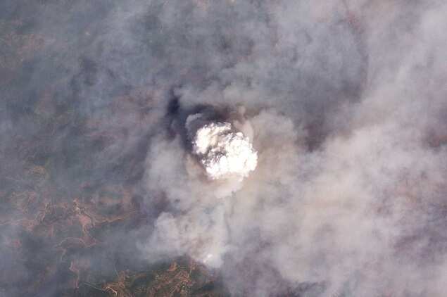
A satellite image shows a type of fire cloud rising from wildfires in Castellon province (Reuters)
Pyrocumulonimbus events are still rare and require a unique set of atmospheric conditions. But the more frequent extreme wildfires become, the greater the chances of seeing these extraordinary storms.Avishek, however, cautioned against treating the France event as proof of a wider shift on its own.“A single event is not proof of a shift on its own, but it fits a pattern that researchers have been flagging for several years: larger burned areas, longer fire seasons, and fires reaching regions of Western Europe that historically saw little serious fire risk,” he said.The kind of extreme heat, drought and fire intensity needed to create a fire cloud has traditionally been associated more closely with Canada, Australia and the western United States. France’s experience suggests that Europe may now be confronting the upper end of that risk more often.“Coming amid a summer that has already produced record evacuations and burned area in France, it reads more as a signal that the upper end of what is possible in European wildfires is shifting upward, rather than as an isolated anomaly,” Avishek said.Research in Australia has already found that conditions favourable for both severe wildfires and fire-cloud formation have become more common in some regions over recent decades. Similar questions are now being asked in Europe after France recorded its first such event.For firefighters, the concern is immediate. Fires that generate their own winds, lightning and spot fires are far harder to predict and control. For scientists, they offer another sign of how extreme wildfires are changing in a warming world.The weather may finally be bringing some relief to southwestern France. Cooler temperatures, higher humidity and the possibility of rain have slowed the spread of the Gironde fire, prompting thousands of people to return home.But this wildfire season has already left behind something more enduring than scorched forests. It has shown that, under the most extreme conditions, a wildfire can become more than a fire. It does not simply respond to the weather around it. It can begin creating weather of its own.


