
In 2014, scientists set off 23 explosions and deployed 3,500 seismographs around Mount St Helens; the experiment helped image a magma reservoir roughly 4 to 15 km beneath the volcano

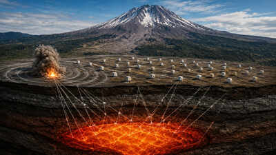
Mount St. Helens is one of the most closely studied volcanoes in the United States, but scientists still cannot directly see the complex system of magma and rock hidden beneath it. In 2014, researchers launched an ambitious experiment to change that. According to the Imaging Magma Under St. Helens (iMUSH) project, a field team used 23 controlled explosions and a remarkably dense network of seismic instruments to send waves through the ground and map what lay beneath the volcano. The results, combined with later seismic studies, helped identify an upper-crustal magma-storage zone roughly 4 to 15 kilometres beneath the volcano.
An experiment beneath a volcano
The 2014 project was part of iMUSH, an interdisciplinary effort designed to investigate the magmatic plumbing system beneath Mount St. Helens. Rather than waiting for natural earthquakes to provide the necessary seismic signals, researchers deliberately generated their own waves. In late July and early August 2014, a field crew of about 70 people conducted the active-source seismic experiment. They created 23 controlled explosions at different distances from the volcano and recorded the resulting seismic waves using hundreds of instruments spread across the region.The explosions were not intended to imitate an eruption. Instead, they acted as artificial seismic sources. When an explosion sends waves through the Earth, those waves travel at different speeds through different types of rock. By measuring how quickly the waves arrive at numerous recording stations, scientists can work backwards to construct an image of the underground structure.
Thousands of instruments
The scale of the experiment was extraordinary. Researchers used roughly 800 to 1,000 Reftek seismic recorders along each of two major profiles, while another 1,600 to 1,800 instruments were deployed in broader arrays extending away from the volcano. Closer to Mount St. Helens, about 300 additional instruments and 920 nodal seismic units were positioned along trails within roughly 7.5 kilometres of the summit. The project also included more than a dozen large arrays around the volcano for recording natural earthquakes.The network was designed to capture seismic waves from many directions. In total, the instruments recorded approximately 80,000 seismic traces from the 23 shots. This dense coverage was important because a volcano is not built like a simple stack of uniform layers. Its interior can contain fractured rock, solidified magma, partially molten material and other complicated structures. Conventional seismic imaging can struggle in such environments.
Turning explosions into an underground map
The researchers used the controlled seismic signals to study how waves travelled through the crust beneath Mount St. Helens. Two long seismic profiles extended as far as 150 kilometres from the volcano. These were designed to investigate structures ranging from the upper crust down toward the boundary between Earth’s crust and mantle, known as the Moho.Closer to the volcano, two rings of controlled shots were positioned at approximately 15 and 30 kilometres from the summit. These provided much denser seismic coverage of the shallower structures beneath and around Mount St. Helens. Additional shots were placed as far as 50 to 80 kilometres from the summit to help probe deeper parts of the crust. The strategy allowed scientists to examine the volcano at multiple scales rather than simply looking for one large underground feature.
Finding the magma reservoir
One of the most important findings to emerge from seismic studies using iMUSH data was evidence for an upper-crustal magma-storage zone approximately 4 to 15 kilometres beneath Mount St. Helens. A low seismic velocity means that seismic waves travel more slowly through that region than through surrounding rock. Such a feature can be produced by hot, fractured or partially molten material, making it an important clue to the location of magma.A 2023 presentation to the Seismological Society of America described the upper-crustal low-velocity zone as the primary magma reservoir, with estimates suggesting it may contain roughly 10% to 12% partial melt. That does not mean the entire region is a giant underground pool of liquid magma. A magma reservoir is better understood as a complex zone containing varying proportions of molten material, crystals and surrounding rock. Much of the material can be partially molten rather than completely liquid.
A complex plumbing system
The seismic results also showed that Mount St. Helens is supplied by a much more complicated underground system than a simple pipe leading from a single magma chamber. Later receiver-function studies using iMUSH data identified variations in seismic properties throughout the crust. Researchers found evidence associated with the shallow magma reservoir as well as unusual high-velocity regions deeper in the crust. These deeper features have been interpreted in different ways, including as accumulated crystallised magma, known as magmatic cumulates, or other high-velocity geological material.Researchers also used measurements of seismic-wave properties such as the ratio between P-wave and S-wave velocities to investigate variations within the crust. These analyses provided additional clues about the distribution and characteristics of the magma-related structures.
Why Mount St. Helens matters
Understanding what lies beneath Mount St. Helens is important because the volcano has a history of powerful eruptions, most famously its catastrophic 1980 eruption. Understanding how magma is stored and transported beneath an active volcano can help scientists better understand what controls volcanic behaviour. The 2014 experiment was particularly valuable because it provided an unusually detailed view of the volcano’s interior. Instead of relying on a handful of naturally occurring earthquakes, researchers created controlled seismic signals and captured them with thousands of instruments. The resulting data helped transform the invisible movements of seismic waves into a three-dimensional picture of the rocks and magma-related structures beneath Mount St. Helens.The experiment did not produce a simple picture of a single underground chamber. Instead, it revealed evidence of a complex magmatic plumbing system extending through the crust, including a major upper-crustal reservoir roughly 4 to 15 kilometres beneath the volcano. For scientists trying to understand how magma moves through an active volcano, those hidden structures provide an important piece of the puzzle.


