
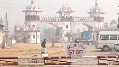
(Representative image) The decision was taken at the 13th meeting of the Survey Officials Committee, led by deputy chiefs of Nepal’s Survey Department and Survey of India, in Lucknow last week (Photo: ANI) NEW DELHI: India and Nepal have decided to use drones to map encroachments along ‘Dasgaja’ areas — the 10-yard no-man’s strip along the international boundary. The two countries will also look at “cross-border occupation”, where citizens of one nation farm, live on or hold land falling on the other side, across the 1,880km open border.The decision was taken at the 13th meeting of Survey Officials Committee, led by deputy chiefs of Nepal’s Survey Department and Survey of India, in Lucknow last week. Officials said the exercise will create a jointly verified technical record of affected areas, which can later help the two countries negotiate removal of encroachments, restoration of land or compensation.The issue returned to Nepal’s political centre stage after PM Balendra Shah told Parliament in May that “Nepal had also encroached on Indian land”. The remark came when Shah was questioned about Limpiyadhura, Lipulekh and Kalapani — territories under India which Nepal claims as its own — and triggered opposition protests. Nepal’s foreign ministry later clarified that Shah was referring to Dasgaja encroachments and cross-border occupation, not territorial claims.Nepal Survey Department spokesperson Dayanand Joshi said, “It has been decided to map cross-border occupation using drones.” He added, “This includes cross-border occupation and also encroachment of Dasgaja.”Border expert and former Survey Department director general Buddhi Narayan Shrestha said the decision could help settle disputes that have lingered for decades. “Indian farmers have encroached on the land of Nepali farmers along the border, and Nepali farmers have also encroached on the land of Indian farmers to some extent. I call this cross-border land grabbing,” he said.Shrestha said his 2005 field study found Indian farmers occupying Nepali land at 84 locations and Nepali farmers occupying Indian land at 27 locations. He said such disputes arose where boundary pillars were missing or mistakes were made during local land use. “It will take some time for technicians from Nepal and India to compile such a list,” Shrestha said. “Once the data is in hand, the decision on how to resolve the issue should be made through negotiations by higher-level officials sitting at the table.Join conversationView All Comments →Share your thoughts in the commentsInsightfulAgreeDisagreeSkepticalConcerningPromisingWorth ReadingBig DevelopmentPost CommentBe respectful · TOI community guidelines”Shrestha cited Nepal’s past border demarcation with China, where local officials from Tibet and Nepal resolved similar disputes through sale windows and compensation. He said nearly 42 per cent of the 8,553 border pillars shown on maps are yet to be installed, making drone mapping crucial for preventing village-level disputes from turning into diplomatic flashpoints.Get the latest India News and Live updates. Download the TOI app.End of ArticleFollow Us On Social MediaVideosModi Pushes AI, Youth And Data Agenda, Tells Secretaries To Break Government Silos And InnovatePirates Hijack Two Ships Carrying 22 Indians Off Yemen And Somalia, Crew Safety Raises Concern‘NEET, Delimitation, Cauvery, Drugs’: Vijay’s Key Requests Before Amit Shah At Tamil Nadu MeetingPolicy Shift Or Just Words? Inside US Envoy Gor’s ‘Kashmir’ Remark That Rattled PakistanJharkhand High Court Stays Soren Govt’s Order To Cancel JPSC Exams, AppointmentsKangana Vs Ramdev: BJP MP Fires Back After Yoga Guru Questions Her Past And Controversial Remarks’Not Mahatma Gandhi’s Congress’: FULL Vande Mataram Rejected At INC Events, BJP Doubts ‘Loyalty’US Body Opposes Mohan Bhagwat’s Visit, Seeks Sanctions on RSS Members Over Religious Freedom ClaimsDJB Tender Scam Row: AAP Questions Why Raghav Chadha Was Never Questioned By InvestigatorsMaharashtra’s Power Shift: Fadnavis Can Now Reverse Ministerial Decisions In Public Interest123PhotostoriesHow to dress in quiet luxury over 40: Elegant fashion trends to try this seasonHow to look expensive without spending a lot of moneyFrom money plants to shankh: 5 Vastu items believed to bring good luck and positivity at homeHow much walking can reverse the health risks of sitting for 8 hours a day? Doctor explains what your body needsWhy does homemade curd turn slimy during monsoon and 3 ways to prevent itThe history of the white shirt: How a simple staple became the ultimate fashion icon10 enchanting baby girl names inspired by fantasy, mythology and folkloreSugar price hike by Rs 8 per kg: 9 natural Indian sweeteners and how to use themOptical illusion personality test: The first thing you spot reveals what’s coming next in your lifeIs apple cider vinegar good for your hair? Benefits, side effects, and the right way to use it123Hot PicksFlorida Police Officer ArrestJoe RootPV SindhuSensex TodayGold Rate TodayFaceless assessmentRSS sanctionZepto internshipPakistan High CommissionTop TrendingShadow the Hedgehog FortnitePakistan High CommissionTwisha SharmaKarnataka MurderKerala MurderAbhijeet DipkeSukesh ChandrashekharRahul GandhiBengaluru RapidoBen Gvir

NEW DELHI: India and Nepal have decided to use drones to map encroachments along ‘Dasgaja’ areas — the 10-yard no-man’s strip along the international boundary. The two countries will also look at “cross-border occupation”, where citizens of one nation farm, live on or hold land falling on the other side, across the 1,880km open border.The decision was taken at the 13th meeting of Survey Officials Committee, led by deputy chiefs of Nepal’s Survey Department and Survey of India, in Lucknow last week. Officials said the exercise will create a jointly verified technical record of affected areas, which can later help the two countries negotiate removal of encroachments, restoration of land or compensation.The issue returned to Nepal’s political centre stage after PM Balendra Shah told Parliament in May that “Nepal had also encroached on Indian land”. The remark came when Shah was questioned about Limpiyadhura, Lipulekh and Kalapani — territories under India which Nepal claims as its own — and triggered opposition protests. Nepal’s foreign ministry later clarified that Shah was referring to Dasgaja encroachments and cross-border occupation, not territorial claims.Nepal Survey Department spokesperson Dayanand Joshi said, “It has been decided to map cross-border occupation using drones.” He added, “This includes cross-border occupation and also encroachment of Dasgaja.”Border expert and former Survey Department director general Buddhi Narayan Shrestha said the decision could help settle disputes that have lingered for decades. “Indian farmers have encroached on the land of Nepali farmers along the border, and Nepali farmers have also encroached on the land of Indian farmers to some extent. I call this cross-border land grabbing,” he said.Shrestha said his 2005 field study found Indian farmers occupying Nepali land at 84 locations and Nepali farmers occupying Indian land at 27 locations. He said such disputes arose where boundary pillars were missing or mistakes were made during local land use. “It will take some time for technicians from Nepal and India to compile such a list,” Shrestha said. “Once the data is in hand, the decision on how to resolve the issue should be made through negotiations by higher-level officials sitting at the table.
Share your thoughts in the comments
Be respectful · TOI community guidelines
”Shrestha cited Nepal’s past border demarcation with China, where local officials from Tibet and Nepal resolved similar disputes through sale windows and compensation. He said nearly 42 per cent of the 8,553 border pillars shown on maps are yet to be installed, making drone mapping crucial for preventing village-level disputes from turning into diplomatic flashpoints.


